Comanche. The name brings up lots of images, many negative - Indians attacking wagon trains, savagely killing people. The Comanche have not had a positive depiction in popular imagination. Like many popular images, these are highly exaggerated and inaccurate. The Comanche were in fact important traders of the plains.
When it comes to the setting most people would imagine Comancheria, the land of the Comanches, as Texas. However the Comanche roamed a large swath of the southern plains, and the far southeast of Colorado was home to some of the Comanche. Like many large tribes the Comanche were divided into groups. The northernmost was the Yamparikas, a name meaning Yamp Eaters. Yamp, or Yampah, is a wild plant native to the West and an important part of Native diets. The bulbs and seeds are edible. There is a Ute band also named Yamparika, not to be confused with the Comanche group.
The Comanche are linguistically related to the Shoshoni dialect and came into the plains from the Great Basin where they separated from the Shoshone. It was the Ute that named them ‘Komanticia’, meaning ‘anyone who wants to fight me all the time.’ Eventually the word got changed to Comanche. The Comanche name for themselves is Numunuu, meaning ‘the people’. The Comanche believed they were created from the earth by the Great Spirit. The Moon was their mother. When storms passed over them they would stay quiet so as not to offend Thunderbird, creator of the storms.
Once they got horses from the Spanish the Comanche expanded onto the plains, pushing the Arapahoes to the south and the Utes to the mountains. The Kiowa, armed with guns from Spanish traders, clashed with them frequently, until the two tribes formed an alliance around 1790, leading to a long lasting compact. This was the time when they were first mentioned by Spanish chronicles in 1705. Horses were a central part of the Comanche identity. The horse represented the wealth of the owner - the more that were owned the more wealth the owner had. The Comanche were great horse tradesmen and filled an important middleman position of the horse trade on the plains.
One important wintering ground for the Comanche was in Colorado, a place called Big Timbers, located close to the Purgatory River Confluence with the Arkansas River. While raiding the Pueblos of New Mexico the Comanche either returned to the Staked Plains of Texas or north to the southeastern plains of Colorado, which led to one of the more dramatic fights between the Spanish and Comanche.
In 1779 New Mexico Governor Juan Bautista de Anza led a large expedition against the raiding Comanches led by a chief named Cuerno Verde (Green Horn), named because he had two buffalo horns in his head dress dyed green. Anza followed the Arkansas River into the San Juan Valley, then crossed Poncha Pass into the area of Salida. From here Anza followed the Comanche into South Park, one of the first Europeans to see this extensive mountain valley. They exited the valley via Ute Pass into the area of Woodland Park, following the Comanche to modern day Rye, south of Pueblo. There he caught up to Cuerno Verde. The great chief, with his best warriors, held off the Spanish and gave their lives while the village escaped. Greenhorn Mountain is named for the great chief.
The battle with Anza came at a time when the Cheyenne were migrating onto the plains from the east. The Osage were also pushing east, cutting off Comanche trade with the Kansa in Kansas and points further east. Then in 1780 or 1781 a massive smallpox epidemic swept the continent, killing approximately a third of the Comanche population. Thousands more Natives from other tribes died as well. This led to the Comanche looking to make peace with the Spanish, which came at a time when Spain was willing to make peace with many of the tribes. There was a peace treaty in 1785 with the eastern bands and then in 1786 when Anza held a peace talk at Santa Fe. The Comanche were not the only ones. Spain made alliances with the Navajo and the Ute, all three tribes being turned against the Apache.
With peace the Comanche began to move closer to New Mexico. A new movement onto the plains caused another repositioning of tribes in Colorado. The Lakota expanded onto the plains to the north, pushing the Cheyenne to the south. In 1820 US surveyors found a large Cheyenne/Arapaho camp at Big Timbers, along with Comanche. However, later that decade, the Cheyenne/Arapaho cut off their friendly ties and began war with the Comanche/Kiowa, eager to take over their New Mexico trade. During this time William Bent arrived, formed an alliance with the Cheyenne and built Bent's Fort at Big Timbers. By 1840 peace was agreed between the four groups and a big council was held near Bent's Fort. The Arkansas River was agreed to be the new border between the Cheyenne/Arapahos and Comanche/Kiowa, with the former staying on the north bank and the latter to the south. With this, Comanches shifted further and further south out of Colorado. They would later be defeated by the US army and forced onto a reservation in Oklahoma. Today they have around 17,000 members enrolled in their nation. Around 966 members, as of a 2021 census, reside in Colorado, continuing the Comanche presence here today.
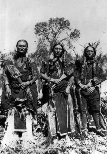
(top photo: Comanche Men, Charles Ohetant (Kiowa), Quinah Parker (the great leader of Comanches in the mid 19th century) Ahko Watchymamsookwat. Traditional dress for men was long fringes of buckskin with hair in two long braids, adding horse hair to lengthen them.Western History Digital Collections, x-32188)
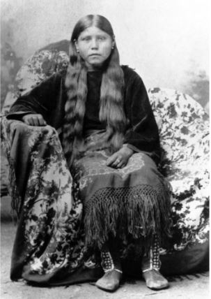
(second photo: Comanche woman, only identified as wife of Oscar Yellow Wolf only. Traditional dress for women was a blouse and fringed dress, made from buckskin. Western History Collection x-32204)
Post submitted by Brian Johnson, Hampden Branch Library.